Onshore and Offshore Exploration of Oil & Gas as well as Geothermal Brine Reservoirs
HYDROSCAN® is an innovative helicopter-based passive seismo-electromagnetic exploration technology which is used to detect hydrocarbon (HC) accumulations up to depths of more than 4,000 m f.i..
3D imaging enables mean depth and multi-reservoir indication.
For all tasks the HC reservoir identification capability includes conventional (anticlinal) traps as well as unconventional non-structural related traps, like occurrences in stratigraphic closures, fault zones, sub-salt and sub-basalt.
![]()
 Airborne Seismo-Electromagnetics for Detection
and 3D Imaging of Hydrocarbon and Geothermal Brine Reservoirs
Airborne Seismo-
Electromagnetic Method
The development of the proprietary system is based on research results obtained over oil and gas fields, where it is found that specific low-frequency (LF) electromagnetic (EM) power spectra are largely raised as compared to dry and tight rock mass.
The observed diagnostic signal data can be related to an electrokinetic conversion associated with HC/brine reservoirs.
Thereby ocean-wave generatic seismic earth noise is the driving excitation force which is changed into an electromagnetic field radiation under the influence of the geomagnetic field.
Thus, a HYDROSCAN survey enables the discrimination between presence and absence of transmissible (productive) HC reservoir zones.
The signal intensity is proportional to HC saturation, permeability and pay thickness expressed by the HC transmissibility which mainly influences the HC productivity of a well.
It opens a wide range of highly beneficial usage, from frontier exploration to field extensions, from prospect de-risking to seismic interpretation support, and from optimization of well placement to reservoir time-lapse monitoring.
![]()
HYDROSCAN information on demand.

Typical frequency spectra indicating
no-HC and HC reservoir zones
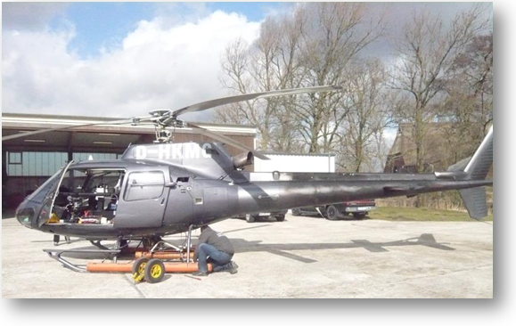
Seismo-EM system equipped at helicopter
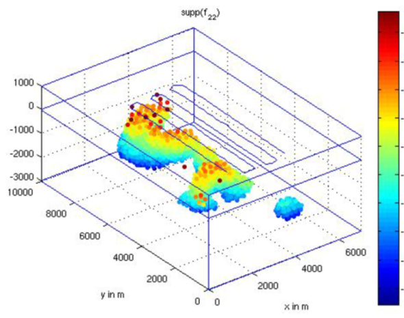
3D imaging enables mean depth and multi-reservoir indication.
Survey & Deliverables
The HYDROSCAN airborne system consists of a high performance measuring instrumentation as well as programs for data acquisition, data processing and 3D inverse modelling.
The exploration procedure comprises:
Data acquisition:
![]() Continuous automatically measurement of the electromagnetic field
Continuous automatically measurement of the electromagnetic field
![]() Low and slow flights
Low and slow flights
![]() Survey line spacing >50 to 200m
Survey line spacing >50 to 200m
Data processing:
![]() Signal analysis
Signal analysis
![]() 3D inverse modelling
3D inverse modelling
Data evaluation and visualisation:
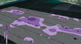
![]() Contour plots indicating receiver and source signal distribution
Contour plots indicating receiver and source signal distribution
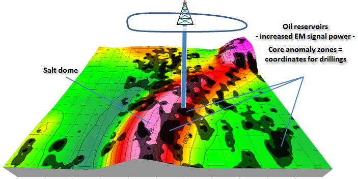
![]() 3D visualisation of results with depth isoline plots of core anomaly zones
3D visualisation of results with depth isoline plots of core anomaly zones
Final report:
![]() Geological interpretation of geophysical results referring the hydrocarbon potential with depth estimation
Geological interpretation of geophysical results referring the hydrocarbon potential with depth estimation
Advantages &
Features

![]() Efficient de-risking tool
Efficient de-risking tool
![]() Discrimination between presence and
Discrimination between presence and
absence of oil & gas
![]() No geographical / surface / infrastructure
No geographical / surface / infrastructure
related constraints
![]() No environmental limitations
No environmental limitations
![]() No need for ground permitting
No need for ground permitting
![]() Quick turn-around
Quick turn-around
from preparation through data acquisition and processing to result
delivery with final report
Case Example -
Offshore Exploration
![]() The exploration
works are part of a re-exploitation plan for
an abandoned oil reservoir which is situated
in the Baltic Sea..
The exploration
works are part of a re-exploitation plan for
an abandoned oil reservoir which is situated
in the Baltic Sea..
Case Example -
Onshore Exploration
![]() By order of an international oil & gas producer a
helicopter-borne seismo-electromagnetic
HYDROSCAN survey was carried out
onshore.
By order of an international oil & gas producer a
helicopter-borne seismo-electromagnetic
HYDROSCAN survey was carried out
onshore.

Research & Development
Extraction and analysis of the exceptional HC- associated seismo-EM signals as well as the development of the required survey instrumentation and processing steps were realized in the frame of R&D projects funded by the German Ministries BMU (Environment) and BMBF (Education & Research).


About us
![]() GEO EXPLORATION TECHNOLOGIES - GET - is a German geophysical service company experienced in exploration of subsurface ressources, structures and properties serving numerous national and international projects since 1986.
GEO EXPLORATION TECHNOLOGIES - GET - is a German geophysical service company experienced in exploration of subsurface ressources, structures and properties serving numerous national and international projects since 1986.